In Partnership With
- Nama Traditional Leaders Association (NTLA)
- Ovaherero Traditional Authority (OTA)
Additional Funding
- European Cultural Foundation
- Medico International
Methodologies
Forums

Following the genocidal campaigns perpetrated against the Nama and Ovaherero, European-style sedentary commercial farms were imposed, and native wildlife nearly eradicated, while the surviving Indigenous populations were confined to ‘native reserves’ a fragment of the size of their ancestral homelands.
Drawing on oral testimony, archival records and fieldwork, we developed novel methods for the reconstruction of historical landscapes to make visible the long-term environmental degradation experienced in Namibia since German colonisation. Environmental degradation is an overlooked colonial legacy which perpetuates genocidal violence today through landlessness, economic deprivation, and intergenerational poverty.
This research explores how to evidence the cumulative and enduring legacies of colonial violence for affected communities seeking environmental reparations and land restitution, amid growing calls for the recognition of colonial violence within ‘loss and damage’ negotiations concerning the impact of climate change.
Namibia's disappearing grasslands
Historically, the trees of central Namibia were few, and far apart. The open savannah, a common biome in southern Africa, is characterised by expansive grasslands dotted with large canopy trees. In Namibia, these grassy pastures historically sustained diverse tribes, including the Ovaherero, Damara, Nama, and San, each with a distinct relationship to the land, and cultural practices shaped by the land’s natural cycles. Many tribes were semi-nomadic, moving across the land with their livestock, attuned to the rhythms of grass growth and water availability.
Today, those grasslands are rapidly disappearing, overtaken by thorny trees and shrubs in a process called ‘bush encroachment’, a sign of land degradation. Bush encroachment occurs when the grass layer of the earth is degraded and overtaken by trees and other woody plants. Once these woody species have proliferated, grasses cannot grow back. Bush encroachment exacerbates the effects of drought and is a stage of desertification.
While there are many possible causes of bush encroachment, including climate change, anthropogenic factors are consistently cited by rangeland experts and ecologists as a significant contributor.
This investigation traces the roots of present-day environmental and social vulnerabilities in Namibia to German settler colonialism at the turn of the 20th century. By examining colonial policies, land use practices, and testimonies on the suppression of Indigenous lifeways, this investigation examines how a century of land dispossession and overgrazing likely contributed to widespread bush encroachment and accelerating degradation of arable and agricultural land.
Led by oral history and indigenous knowledge, we compiled, analysed, and cross-referenced archival maps, photographs, and documents to reconstruct Namibia’s landscape as it would have been before German colonisation. We developed novel methods to quantify environmental changes since German rule, offering ways to account for the enduring impact of settler-colonialism and genocide on Indigenous peoples in Namibia and elsewhere.
Background
The German settler-colonial project sought to create additional ‘living space’— or Lebensraum, a term coined by the geographer Friedrich Ratzel — for Germany. Ratzel argued colonisation was central to Germany’s future, in particular the settlement and cultivation of arable land [1]. Ratzel saw great potential for agricultural colonisation in ‘German South-West Africa’ and was one of many German thinkers to push for a German empire [2]. The concept of Lebensraum became highly influential, informing Germany’s expansionist and genocidal policies later in the century when it came under Nazi rule.
During the early 20th century, the German administration seized the majority of arable land in present-day Namibia and imposed a new system of land ownership and exploitation along racial lines. Previously open, pastoral lands were divided and given to European settlers, and traditional land management was outlawed.
Mission stations
Christian mission stations, first established in Namibia from the early 1840s, were the first step toward German colonisation. These mission stations doubled as weather stations that recorded data and environmental observations which informed later colonial expansion.
After the 1884 Berlin Conference, which formalised a common strategy for the European colonisation of Africa, the German Empire accelerated its plans for settlement by deploying surveyors to search for water and identify the best lands for farming. The data they collected, along with the maps, photographs, and written observations produced taken by explorers and missionaries, directly informed German settlement on the most fertile land.
Land grabs
German expansion accelerated from the late 19th century through landgrabs and contracts, many of which were coercive or misleading. German colonists took advantage of events like the 1896-97 Rinderpest epidemic to accelerate the colonial seizure of land [3]. Following the death of almost 90% of all tribal cattle, local chiefs—many of them Herero—were pressured to sell their ancestral land [4].
When the Ovaherero and Nama resisted the violence being enacted against them and their lands, the Germans issued extermination orders against both peoples, in 1904 and 1905 respectively. This began a genocidal military campaign, between 1904 and 1908, characterised by mass slaughter and land theft. As part of this genocidal campaign, the German army weaponised the environment, pushing Indigenous populations out of their homelands and into the desert to die.
The 1904–08 genocidal war cleared ground for the establishment of a new system of white settler agriculture. Under the 1905 Expropriation Order, the German administration confiscated all Ovaherero and Nama land and cattle. Soldiers involved in the genocidal campaign received 5,000 hectares of land as a reward, while new settlers could acquire land at symbolic prices. The colonial government subsidised fencing, drilling, and dam construction, and compensated settlers for livestock losses, providing extensive material support to entrench the settler economy.
This landgrab also introduced a system of private ownership of property through which settler farmers carved up large areas that had been Indigenous pasture lands. This system of ownership still defines Namibia’s land regime today, wherein less than 0.5% of the population, primarily descendants of settlers, hold more than 70% of arable land.
The native survivors of Germany’s genocidal campaign were confined to much more limited and rigid ‘reserves’ and ‘homelands.’ Their way of life was disrupted both by the enforcement of these boundaries and by a series of policies, introduced throughout German rule, designed to disrupt their relation to the land and exploit it for the benefit of the German settler society. These policies were later adopted and enforced by the South African apartheid regime after the First World War.
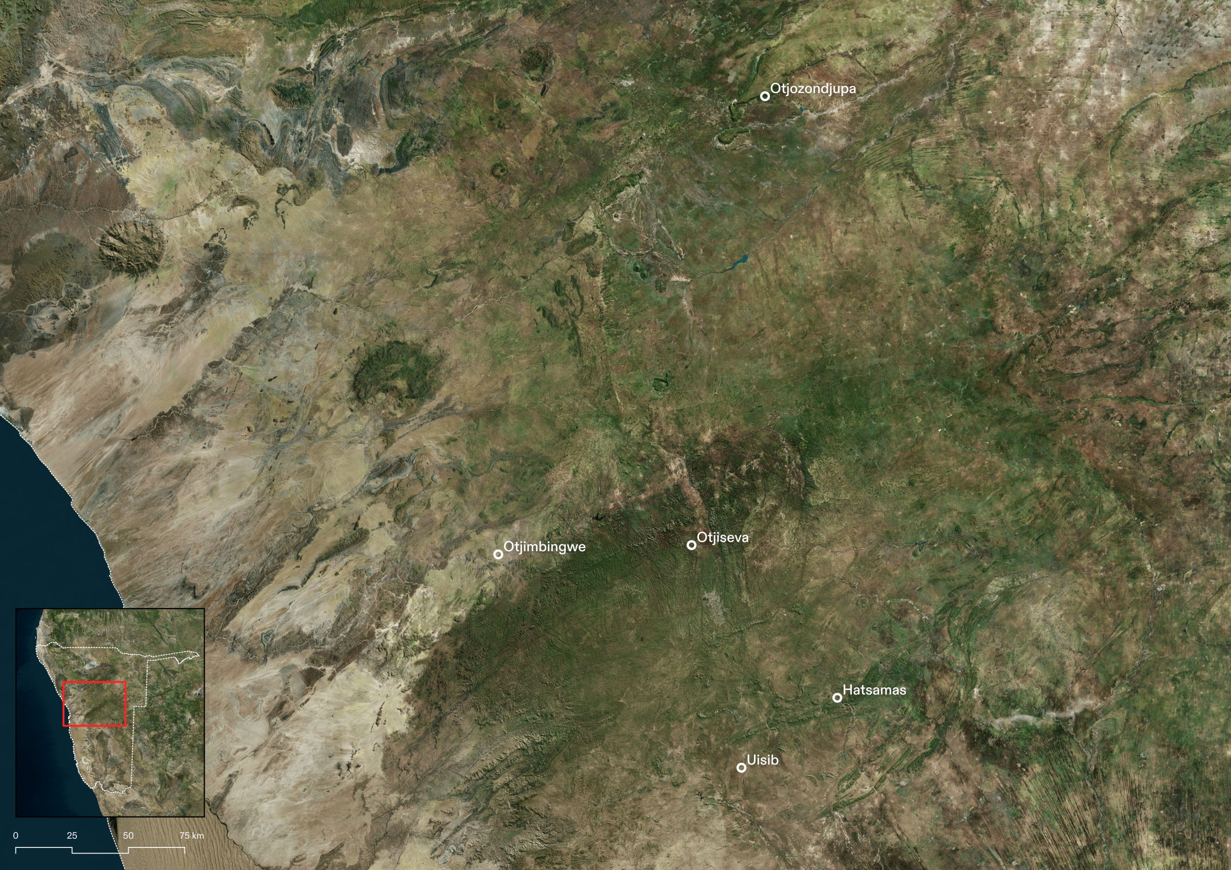
Retracing traditional paths: Otjimbingwe
Germany’s colonisation of Namibia proceeded along two main axes from the coast, starting at the ports of Lüderitz in the south and Swakopmund in the north, and cutting through the desert into the highlands.
Otjimbingwe, located along Swakop River trade routes, became the site of an early mission station in the mid-1800s and later the first seat of the German colonial administration under Heinrich Göring (father of the Nazi leader Hermann Göring). In 1898, it was designated one of the first ‘native reserves’, inaugurating a system of spatial control later continued by the South African apartheid regime. The boundaries of the Otjimbingwe ‘communal’ land today derive from this reserve.
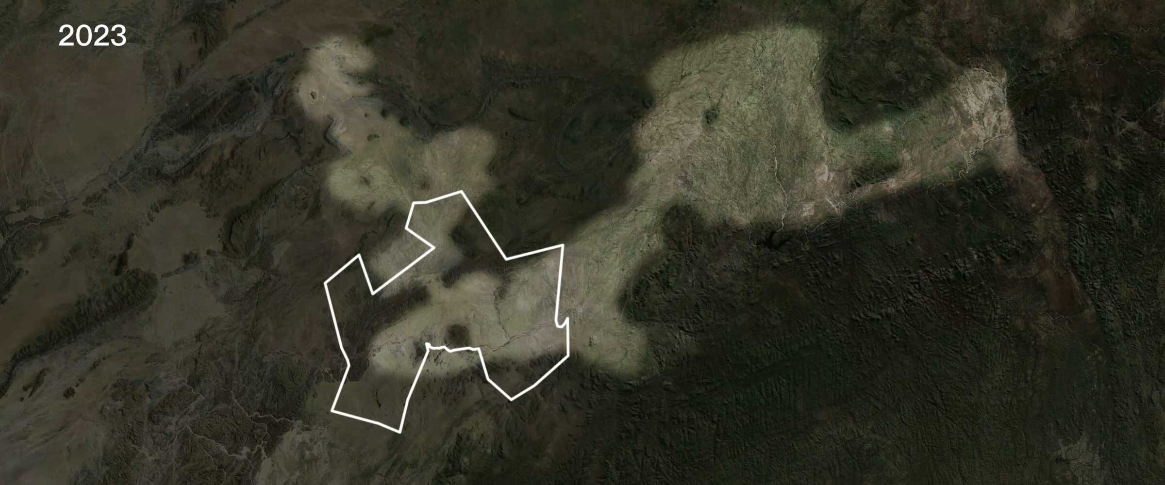
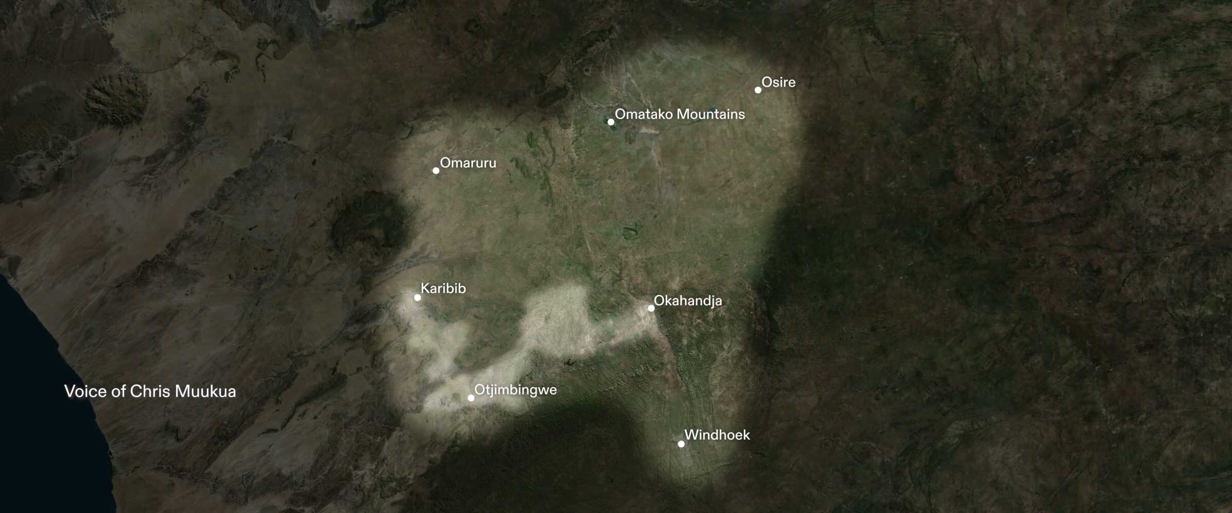
Before colonial enclosure, the Ovaherero practiced seasonal movement, allowing adaptation according to environmental cycles and regeneration of grasslands. An elder from Otjimbingwe, Chris Muukua, described how Ovaherero families once grazed cattle across a vast territory stretching from Kharbib to Okahandja, more than twice the area available to them now. By mapping the contours of the land and identifying low-lying terrain, we deduced the possible shape and reach of this former grazing land, which stands in stark contrast to the constricted boundaries of Otjimbingwe’s contemporary ‘communal’ land. A leading cause of land degradation and bush encroachment today is overgrazing—a phenomenon that we can trace to this historical confinement and restriction of movement. Chris told us that on modern-day Otjimbingwe’s 90,000 hectares, more than 8,000 people and their livestock face water shortages and limited grass availability.
Settler farms were carefully organised during German rule to maintain exclusive access to precious water resources. A 1914 policy formalised this control of resources by granting landowners the right to half the width of any adjacent rivers [5]. Colonial Governor Friedrich von Lindequist promoted further settlement by expanding water infrastructure, establishing a state-funded drilling programme to bore wells across the territory—a practice continued under South African rule [6].
German dam projects also functioned to consolidate control of water in colonial hands. Many unfulfilled German plans for dams were later adopted and built by the South African regime. Chris explained how large, South African-built dams located upstream the Swakop River have severely reduced water availability for the Otjimbingwe community.
Reconstructing lost landscapes: Hatsamas
In 1898, plans for a dam at Hatsamas—located 60 kilometres east of the capital city of Windhoek—were drawn up by a German engineer, Theodor Rehbock, who was sent to survey the area for settler farming. He analysed soil samples for fertility, calculated yields, and recommended borehole drilling. Rehbock referred to the presence of Nama chiefs in Hatsamas as proof of the land’s value, exploiting Indigenous knowledge to guide colonial expansion.
Elders from Hatsamas told us that those who used to live there were coerced off the land through unfair deals. In the area we visited, one family owns most of the entire north side of the river while dozens of families are concentrated in the land to its south, part of the Rehoboth ‘communal’ land.
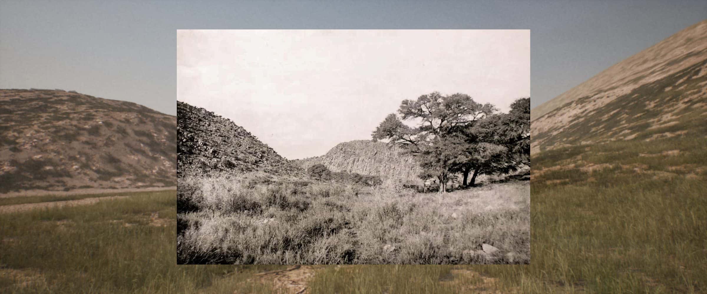
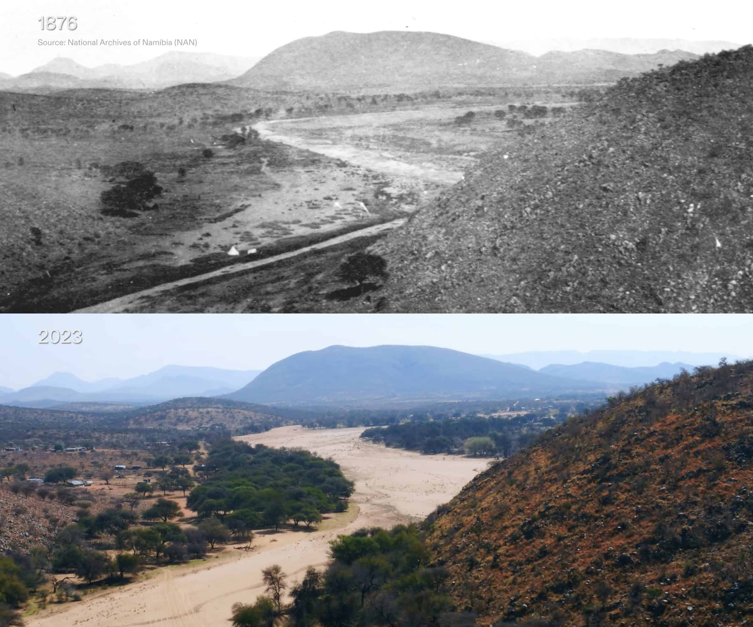
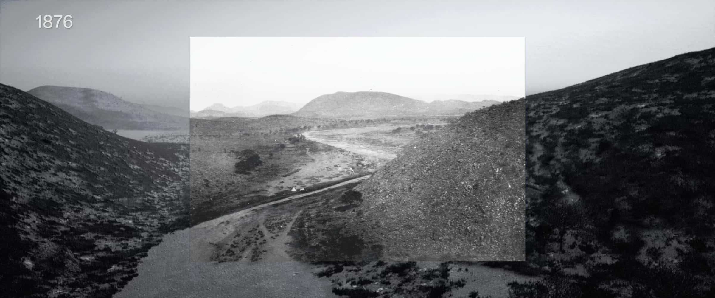
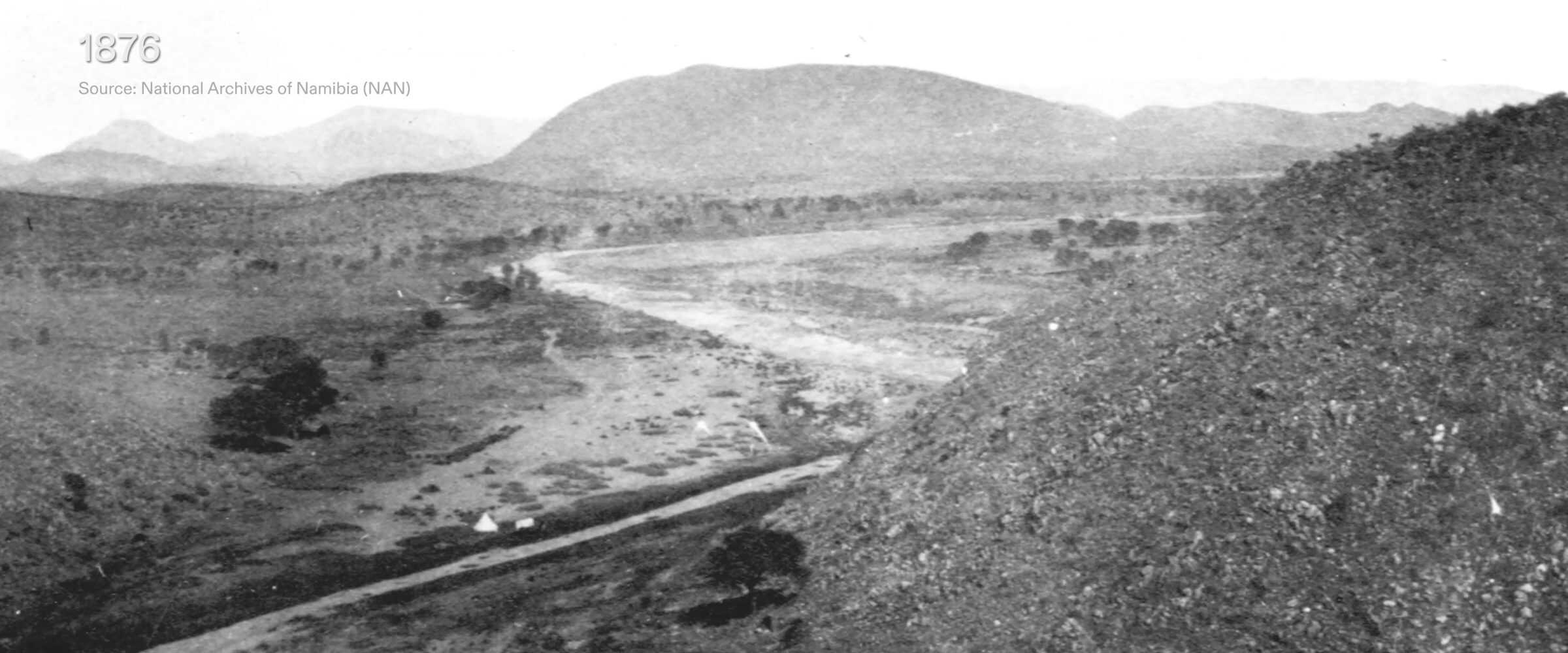
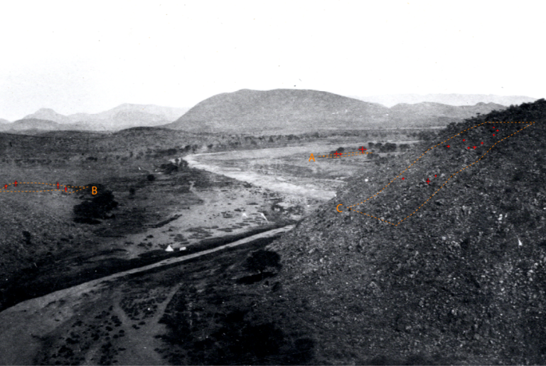
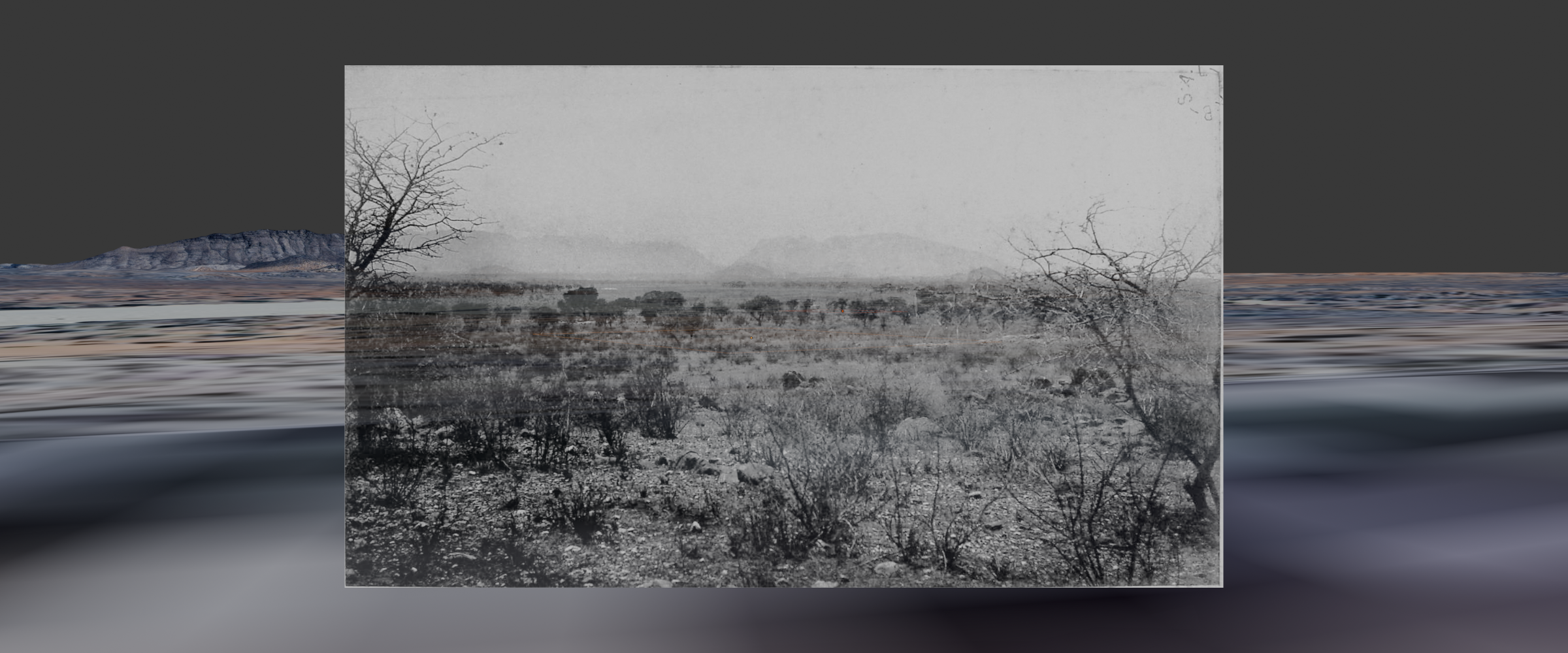
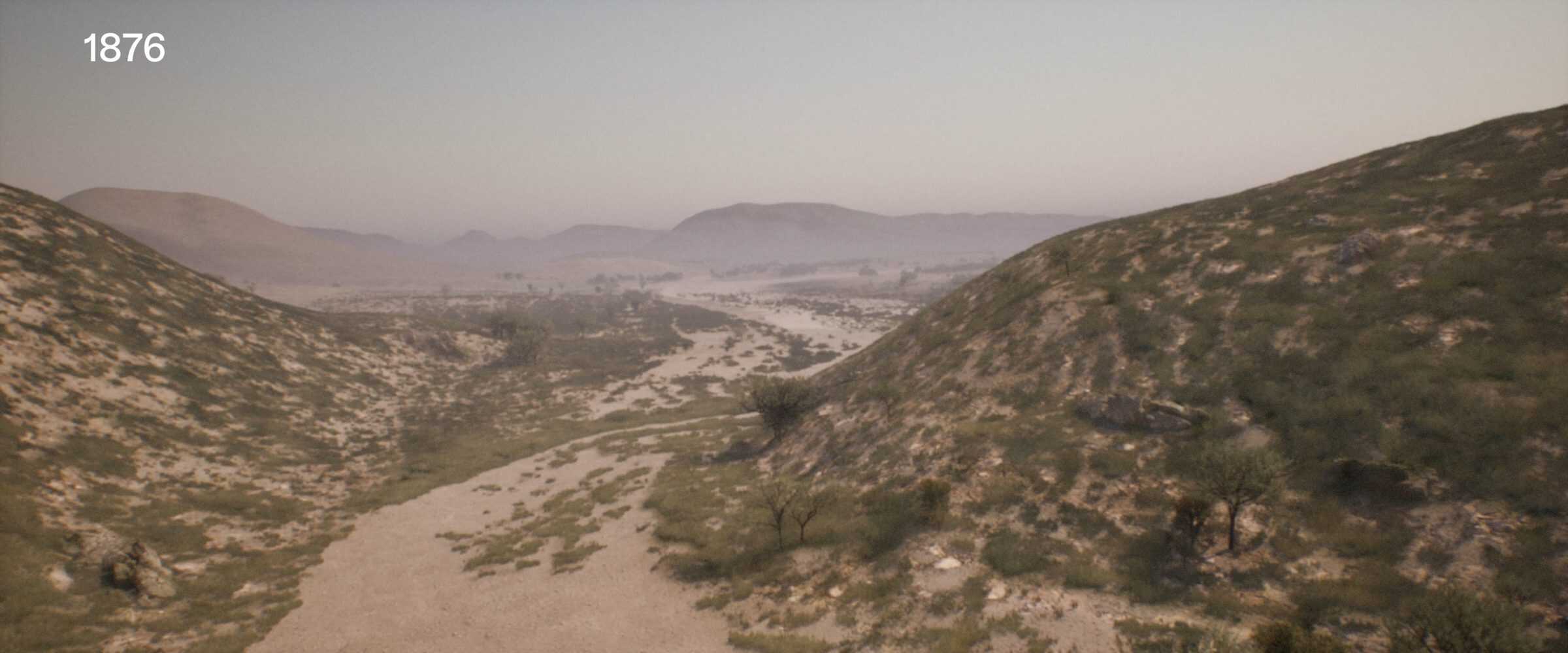
W.C. Palgrave, a British diplomat who had passed through the area two decades earlier in 1876 described dense grasses in his diary. He also took a series of photographs which we positioned in virtual space and used to reconstruct the landscape as it was before German arrival.
Indigenous farmers Margaret Brandt and Lazarus Arebeb also testified to the prior richness of the land, recalling a time when their cattle had enough grass to eat. Today, Margaret says, the land is too dry to support enough grass for the cows to eat, meaning they are unable to produce milk.
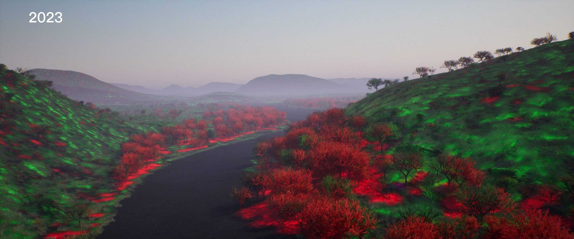
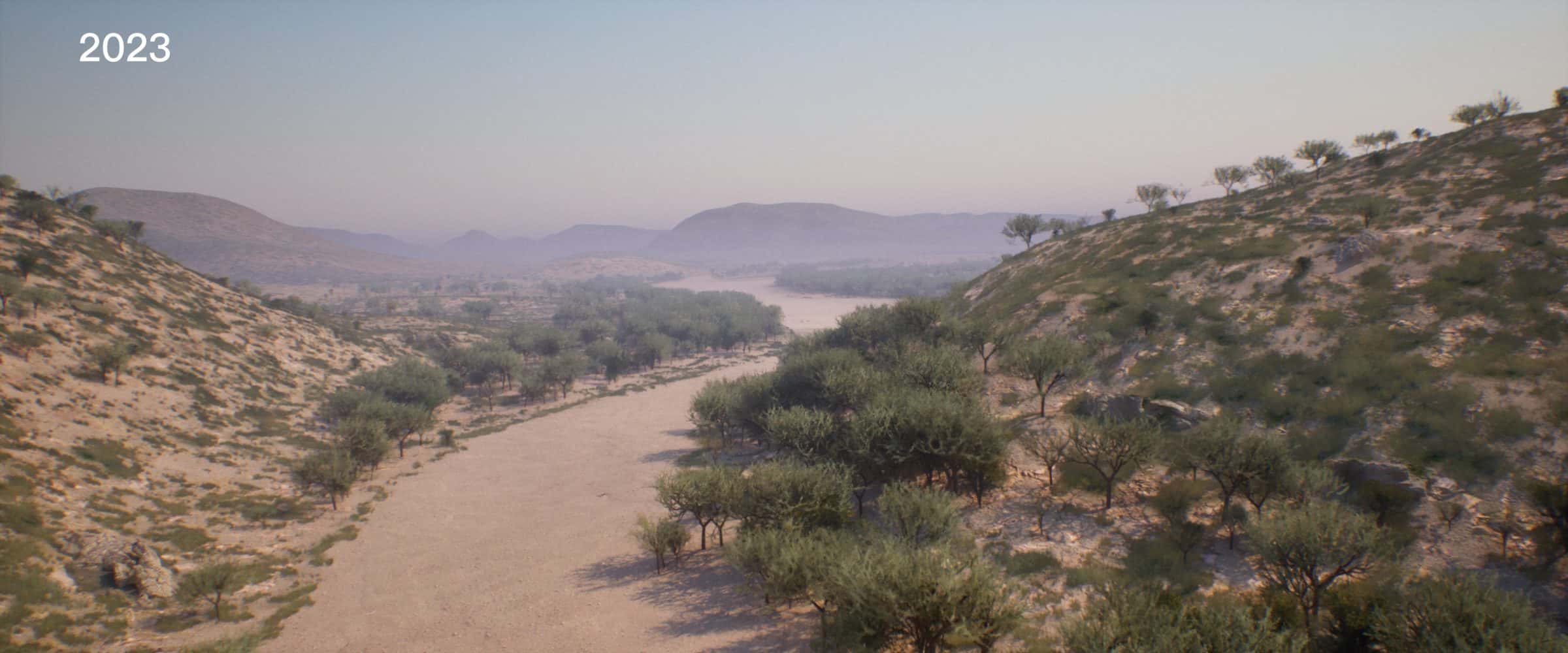
At Hatsamas, oral history guided our digital reconstruction of a once grass-rich landscape with diverse Indigenous plants. Historical photographs from Palgrave and Rehbock, early aerial photography, and contemporary satellite imagery allowed us to further reconstruct what the landscape would have looked like at various moments in time and visualise the progressive growth of bush and disappearance of grasslands over a century. We also conducted a detailed quantification of bush density within one of Palgrave’s photographs in collaboration with rangeland scientist Jerome Boys, and found an average ten-fold increase of bush in Hatsamas since 1876 (see methodology used below).
Dispossession as preservation: Waterberg
Otjozondjupa, better known today as the Waterberg Plateau, was a sacred place for the Ovaherero and the site of pivotal battles over the course of the genocide.
Since Germany’s genocidal campaign, the Ovaherero have been barred from returning to Otjozondjupa: first, through the privatisation of land, and later, through the designation of the plateau as a ‘nature reserve’ in 1972—another facet of dispossession.
Under the pretext of conservation, nature reserves sever the environment from the people that had previously sustained it. Despite these supposed conservation-related designations, the areas around Waterberg today are some of the most impacted by bush encroachment in Namibia.
Methodology
Landscape reconstruction using historical photographs and oral history
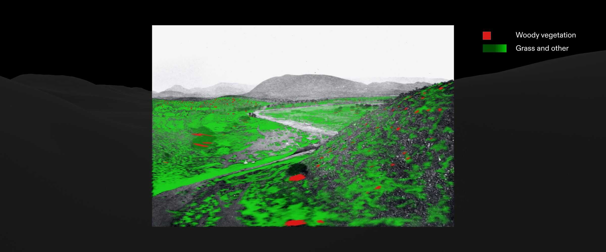
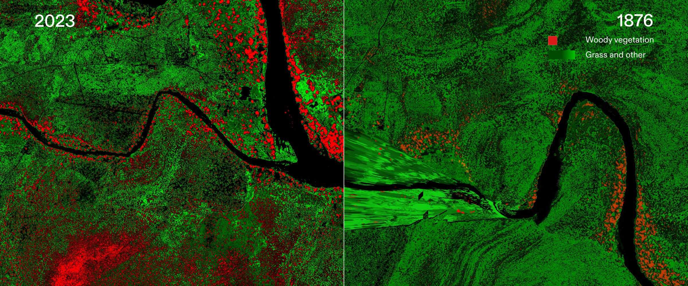
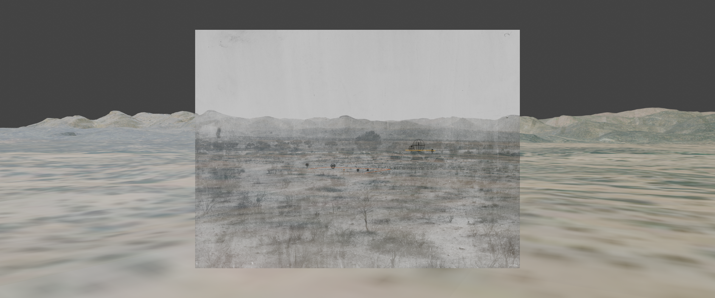
The shades of grey in historical photographs index the different types of vegetation that were present. Drawing upon a key 1876 image from Palgrave’s expedition, we analysed the clustering and position of these shades in relation to landscape features such as rivers and hills. Through this combined reading of context and tone, we coded bush in red and grass and other similar species in green, creating a 3D vegetation map of the landscape as it would have been in 1876. We used this vegetation map, which covers only the narrow perspective of the photograph, to approximate what the rest of the landscape would have looked like in a wider interpolated vegetation map of 1876.
The green and red colour values within the vegetation map reflect the density and size of the grasses and trees. These maps were imported into Unreal Engine, a video game engine with advanced 3D rendering and procedural modelling capabilities, which used the encoded values to generate a three-dimensional reconstruction of the landscape.
Using the same process, we generated vegetation maps for the earliest available aerial imagery of the area (1972) and for satellite imagery (2023). This method allowed us to create an animation in which each frame represented a single year, interpolating between the 1876, 1972, and 2023 maps. We inputted the interpolated map sequence into Unreal Engine, which generated a unique 3D model for each frame. The result visualises the change in the landscape between 1876-2023.
Our model of Hatsamas’ historic grasslands before German colonisation was informed both by what we could observe in archival photographs as well as what we learned from the oral histories shared by Indigenous descendants, who taught us about Hatsamas’ indigenous species, including the Hoodia plant, Devil’s Claw, and Aloe Vera.
Our reconstruction of Namibia’s lost landscape builds on previous studies of environmental history, including the work of Rick Rohde and Tim Hoffman, who first used Palgrave’s photographs in a repeat photography analysis of bush cover change. [7]
Quantifying bush density changes between 1876 and 2023
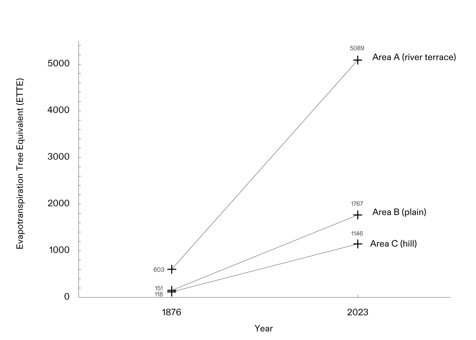
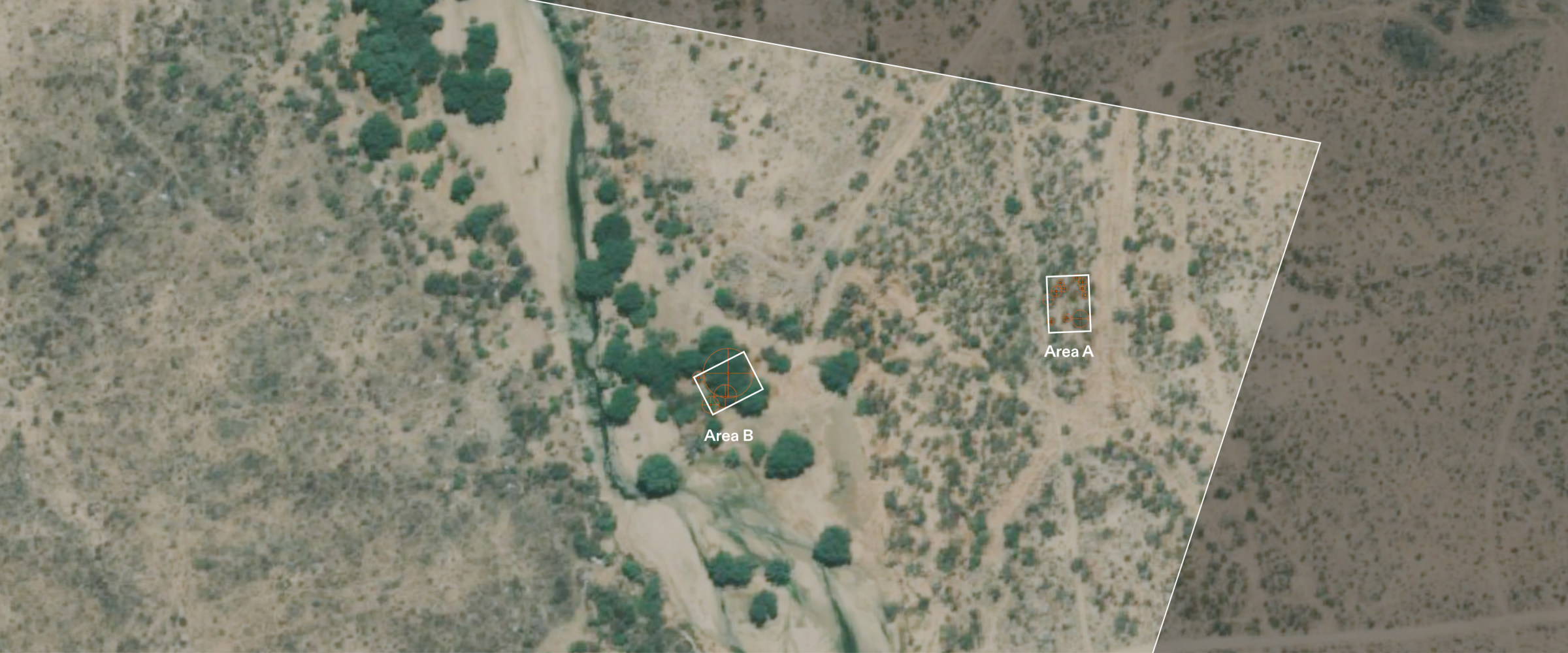
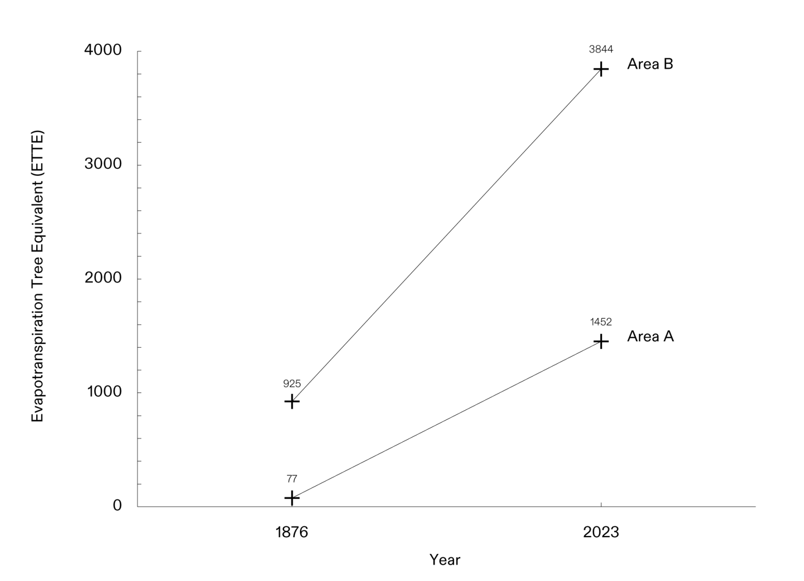
Working with rangeland scientist Dr Jerome Boys, we then conducted a close quantitative analysis of bush density change in Hatsamas between 1876 and in 2023, modelling visible trees in the available photographic materials and measuring their height, canopy diameter, and canopy height in each period. These measurements allow us to quantify the bush using a unit of measurement called the Evapotranspiration Tree Equivalent (ETTE) using a tool developed by Boys. The Evapotranspiration Tree Equivalent is a way of quantifying biomass and is used to assess whether the total mass of woody species in a given area is greater than the healthy baseline, a threshold determined by long-term average rainfall.
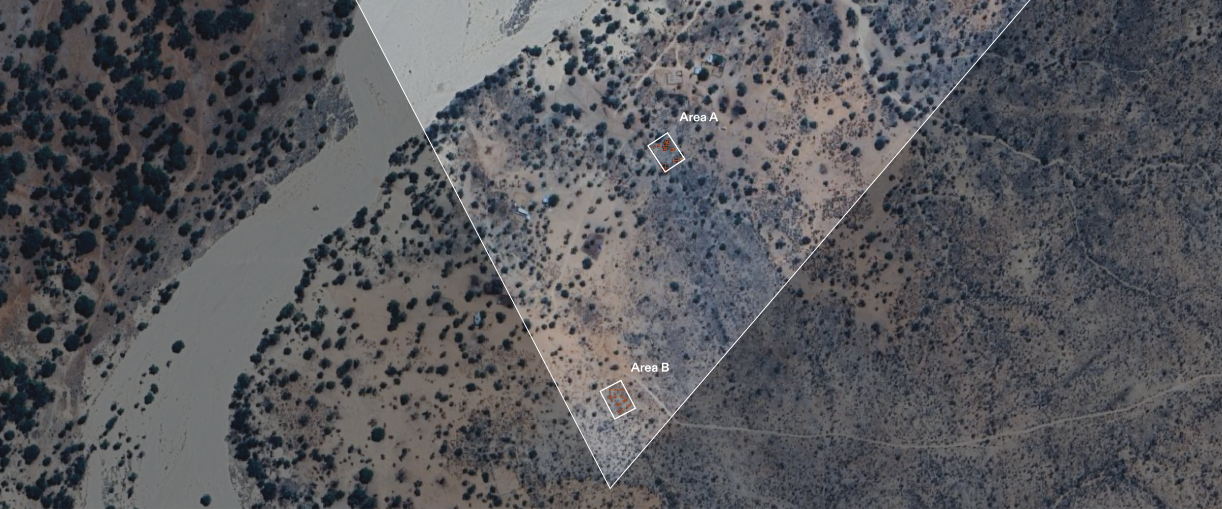
We conducted our analysis in three sample areas in Hatsamas—a river terrace, a flat plain, and a hill—each measuring 40 by 60 metres and characterised by distinct landscape features. These areas were chosen based on classifications typically used in botanical analysis and those referenced by Rohde and Hoffman in their environmental history study of Hatsamas.
Technical findings
Hatsamas
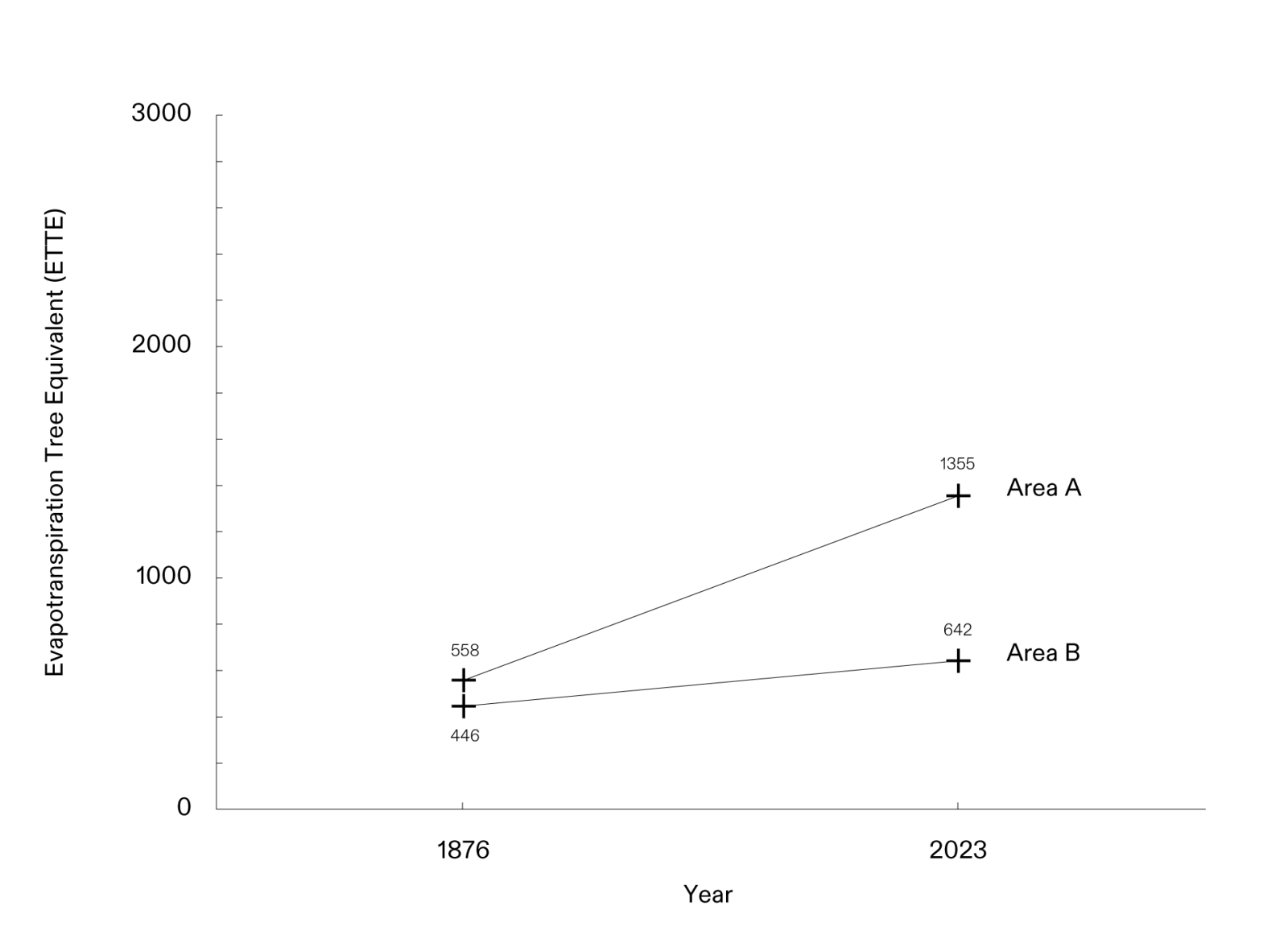
For each area, we calculated the rate of change in bush density between 1876 and 2023, finding eight-, ten-, and twelve-fold increases, respectively. Dr. Boys’ field analysis found that encroachment is likely even more severe than our calculations indicate because smaller species of bush are not visible or measurable in the available photographs.
We repeated this method in two other sites – Otjiseva (a settler farm since the early 20th century) and Uisib (an area within the Reheboth communal land) – and found that both sites experienced a dramatic increase in bush density since colonisation, supporting Indigenous accounts linking environmental degradation to the timeline of the colonial land regime.
Otjiseva
The Otjiseva site saw an average increase in bush density of 12 times between 1876 and 2023 based on an Mean Annual Percipitation of 370mm.
Uisib
The Uisib site saw an average increase in bush density of 2 times between 1876 and 2023 based on a MAP of 240mm.
Case study areas
Conclusion
Our research shows how the ongoing environmental degradation in Namibia is part of a colonial and genocidal continuum. The genocide that began at the hands of German colonisers was not a single event but rather must be understood as a process, which evolved from imperial land grabbing, escalated through a military campaign, and resulted in a system that, even today, perpetuates the dispossession of Indigenous peoples and privileges the interests of the descendants of settlers.
As the most arid nation in sub-Saharan Africa, and one of the least responsible for the human-induced climate crisis, Namibia’s minority tribes are at the forefront of the struggle for intergenerational environmental justice. Working with descendants of Nama and Ovaherero survivors and listening to their inherited testimonies, we were able to digitally recreate lost life-worlds not sensible to the colonial archive. By developing tools to quantify the signs of land degradation, we begin to see the extent and long duration of the colonial crimes perpetrated against Namibia’s Indigenous people. These tools also offer the means to evidence and account for environmental violence within Indigenous demands for reparations and restitution in Namibia and across the post-colonised world.
[1] Ratzel, Friedrich. Politische Geographie, 1897, Oldenbourg, 99
[2] Ratzel, Friedrich. Die Aussichten unsers südwestafrikanischen Schutzgebietes. Die Grenzboten, 51. Jg, Nr. 4, S. 171–175, 1892
[3] David Olusoga and Casper W. Erichsen, The Kaiser’s Holocaust: Germany’s Forgotten Genocide, Paperback edition (Faber and Faber, 2011), 101–2
[4] ibid
[5] Deutsches Kolonialblatt, 1914, 327. Staats und Universitätsbibliothek Hamburg Carl von Ossietzky
[6] Organisational plan for water development in German South-West Africa, 1906. Bundesarchiv
[7] Richard F. Rohde and M. Timm Hoffman, ‘The Historical Ecology of Namibian Rangelands: Vegetation Change since 1876 in Response to Local and Global Drivers’, Science of The Total Environment 416 (February 2012): 276–88, https://doi.org/10.1016/j.scitotenv.2011.10.067.